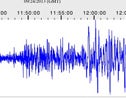
College of Charleston Geology Professor Steven C. Jaume, says the September 24, 2013 Mw 7.7 Pakistan earthquake was so strong that it clearly registered on EarthScope Transportable Array seismometers through South Carolina.
 [Related: Read about students installing the seismometers.]
He says it likely occurred on a branch of the Chaman Fault system in southwestern Pakistan. This fault is a strike-slip fault, similar to the San Andreas fault of California. Other large earthquakes have occurred on this fault system, including a 1935 earthquake near Quetta, Pakistan, which killed several tens of thousands of people.
[Related: See an animation of the seismic wave motion across the USA.]
While yesterday’s earthquake is in a remote region with a low population, researchers at both the U.S. Geological Survey and the World Agency of Planetary Monitoring and Earthquake Risk Reduction in Switzerland forecast fatalities to reach above 1,000. The population in this region generally live in mud brick homes, which are very vulnerable to seismic shaking.
Pakistani news sources have reported a new island appearing in the Arabian Sea just off the south coast of Pakistan. This is most likely a “mud volcano” island, formed by an eruption of pressured mud. Similar islands were created during an earthquake on the coast of Pakistan in 1945 and as recently as 2011 a new mud volcano island was featured on the National Geographic Society’s website.
For more information, contact Steven C. Jaumé at 843.953.1802 or jaumes@cofc.edu.


