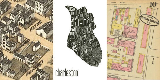
Joe McNeill ‘06 was on the hunt for an architecture job when he got the itch to draw. Inspired by neighborhood maps created for big cities such as Chicago and New York, McNeill decided to create a stylish illustration of the neighborhoods of the Holy City. The result: a silhouette of the peninsula stuffed with 40 or so polygons representing neighborhoods and notable landmarks.
The maps have been selling like hotcakes around town since McNeill made them available for purchase. Not only attractive, the maps are educational. Except the city planning staff, who knew that the Silver Hill-Magnolia neighborhood sprawled across The Neck? Moreover, who knew that downtown Charleston contained so many tiny and unique communities?
“It was an attempt to give identity to these neighborhoods,” McNeill says of his art. “They already had identities, I just think many Charleston residents didn’t even know what they were.”
McNeill, who majored in Historic Preservation and Community Planning, has since found work as a junior architect in the Portland, Ore., office of ZGF Architects. And though he’s moved on to designing buildings for clients in healthcare and higher education, he has fond memories of his stint as a cartographer, no matter the challenges of reducing one of the world’s most dynamic cities to a two-dimensional drawing.
“That was kind of the fun,” says McNeill. “Giving yourself headaches late at night, trying to squeeze things in.”
When researching Charleston neighborhoods, McNeill consulted city tax maps and Sanborn fire insurance maps. Comparing older maps with more contemporary versions, McNeill gained an appreciation for Charleston’s 350-year evolution. New buildings came and went, creeks became filled, and the rural areas fringing the city gave way to development.
“It’s just fascinating to see how the city’s changed,” he says.
To help place McNeill’s Charleston map in some context, we asked adjunct architecture professor and Charleston historian Bob Stockton, who regularly teaches students pursuing a degree in Historic Preservation and Community Planning, to list other important maps in the city’s history.
McNeill had been a student of Stockton’s a decade ago, taking Stockton’s Modern Charleston architecture course, which McNeill recalls as “fantastic.”
“I learned so much about Charleston,” he says.
Here’s Stockton’s take on the most important maps in Charleston history, many of which can be found online or in the South Carolina Room of the Charleston County Public Library on Calhoun Street in Charleston.
The Grand Modell of Charles Town
In 1663, King Charles II granted eight English noblemen, known as the Lords Proprietors, the colony of Carolina. In 1670 the first permanent English settlement in the colony, Charles Towne, was founded on the west bank of the Ashley River (what is now known as Charles Towne Landing).
By 1680, settlers had moved the settlement a few miles to the tip of the Charleston peninsula, otherwise known as Oyster Point. As Stockton explains:
To plan a new colonial city, the Lords Proprietors sent over a “Modell” for towns at Oyster Point, Jamestown and Stony. The original “Modell” has been lost, and the illustration shown here is a ca. 1720 revised version.
The Lords Proprietors’ instructions for laying out the town have survived, and the map demonstrates that their orders were followed. The instructions called for “streets running straight” and that is reflected in the classical grid pattern of the “Grand Modell.” The Lords Propietors wanted the principal streets to be laid out 60 feet wide and the secondary streets 30 feet wide. Indeed, Broad, Meeting and East Bay streets were laid out 60 feet wide, and the secondary streets, such as Tradd, Queen, Church, etc., were laid out 30 feet wide. The blocks and lots were large for a urban situation, and over time were broken up, resulting in a more irregular street pattern and smaller lots.
Ichnography of Charles-Town at High Water, 1739
By 1739, settlers in Charleston had survived the scourge of pirates, battled with Yemassee Indians and established a bustling port, partly through a heavy slave trade. Some of the city’s most iconic buildings started being built, as well as fortifications that survive to this day (though most have to be excavated to be seen). As Stockton says:
The 1739 map illustrates how the town had evolved by that year. The sites of important buildings such as St. Philip’s Church, the Congregational Meeting House and the Beef Market are shown. The map also shows the outline of the city wall, with its bastions, redans, etc. The wall along the Cooper River waterfront was constructed of masonry, while the other three lines were earthworks, a palisade and a moat. The land portions of the wall actually had been taken down by 1739, but the curtain line along the Cooper River remained in place. Beyond the curtain line, extending into the Cooper River, were private wharves, some identified as “bridges,” a hold-over of an ancient use of that word.
Ichnography of Charleston at High Water, surveyed for the Phoenix Fire Company of London, 1788
By 1788, Charles Towne had survived being under siege, and then capture, during the Revolutionary War. After the United States established its independence from Britain, the city changed its name to Charleston. And while a new country was getting on its feet, the College of Charleston was also forming, making use of a barracks in the area now dominated by Randolph Hall. As Stockton says:
The 1788 insurance map shows many of the city’s building, indicating whether they were masonry or wood construction. The map also shows major features such as the colonial barracks (upper right), which had been given to the recently chartered College of Charleston, and Gadsden’s Wharf (lower right) on the Cooper River, which was the largest wharf development in America.
P. Bridgens & Robert. Allen, An Original Map of the City of Charleston, 1852, detail
By the 1850s, Charleston and the rest of the country were on the brink of Civil War, and, since the South would lose the war, economic ruin. This map shows the U.S. Custom House (lower left), which began construction in 1849 but was disrupted by the war. According to Stockton:
The Bridgens & Allen map is a very accurate survey of the streets and buildings of Charleston in the mid-nineteenth century. It shows the precise configuration of all buildings and indicates whether they were of masonry or wooden construction.
C. Drie’s Bird’s Eye View of Charleston, 1872, detail
By 1872, the war was over and Charleston was beginning its economic recovery. C. Drie’s Bird’s Eye View of Charleston shows detailed renderings of Charleston as it expanded northward. Stockton deems the map “another mostly accurate resource depicting the city’s buildings.”
Sanborn insurance map, 1884, detail
In 1866, the Sanborn company made its first map. Since then, the company has made 1.2 million more, documenting the building history of more than 12,000 towns and cities across America. Originally used to determine fire insurance liability in urban areas, Sanborn maps have come to be loved by researchers, who can compare maps made decades apart to chart the course of growth and decline in a city, block by block. In regards to the Sanborn maps of Charleston, Stockton says:
The Sanborn maps of 1884, 1888, 1902 and 1944 are an invaluable resource, as they show the configuration of buildings, construction materials, and the use to which buildings were put. Changes over time can be documented by comparing the sequential maps.
Charleston County GIS map, 2012
Lastly, Stockton recommends checking the offerings of Charleston County’s Geographic Information Services. While primarily used for tax purposes, the maps also feature satellite images that provide unique perspectives of the city.
“These are updated from time to time,” says Stockton, “and sequential maps can be compared to show changes in the topography of the city.”


